We use cookies to ensure our site functions properly and to store limited information about your usage. You may give or withdraw consent at any time. To find out more, read our privacy policy and cookie policy.
Manage Cookies
A cookie is information stored on your computer by a website you visit. Cookies often store your settings for a website, such as your preferred language or location. This allows the site to present you with information customized to fit your needs. As per the GDPR law, companies need to get your explicit approval to collect your data. Some of these cookies are ‘strictly necessary’ to provide the basic functions of the website and can not be turned off, while others if present, have the option of being turned off. Learn more about our Privacy and Cookie policies. These can be managed also from our cookie policy page.
Strictly necessary cookies(always on):
Necessary for enabling core functionality. The website cannot function properly without these cookies. This cannot be turned off. e.g. Sign in, Language
Analytics cookies:
Analytical cookies help us to analyse user behaviour, mainly to see if the users are able to find and act on things that they are looking for. They allow us to recognise and count the number of visitors and to see how visitors move around our website when they are using it. Tools used: Google Analytics
Geographic Information Systems (GIS) Strategic Plan
Share Geographic Information Systems (GIS) Strategic Plan on FacebookShare Geographic Information Systems (GIS) Strategic Plan on TwitterShare Geographic Information Systems (GIS) Strategic Plan on LinkedinEmail Geographic Information Systems (GIS) Strategic Plan link
The GIS survey has closed.
The Geographic Information Systems Division (GIS) is developing a 5-year Strategic Plan which will be used as a guide to update and improve its services and/or products. Your survey response will be used in the development of the Strategic Plan.
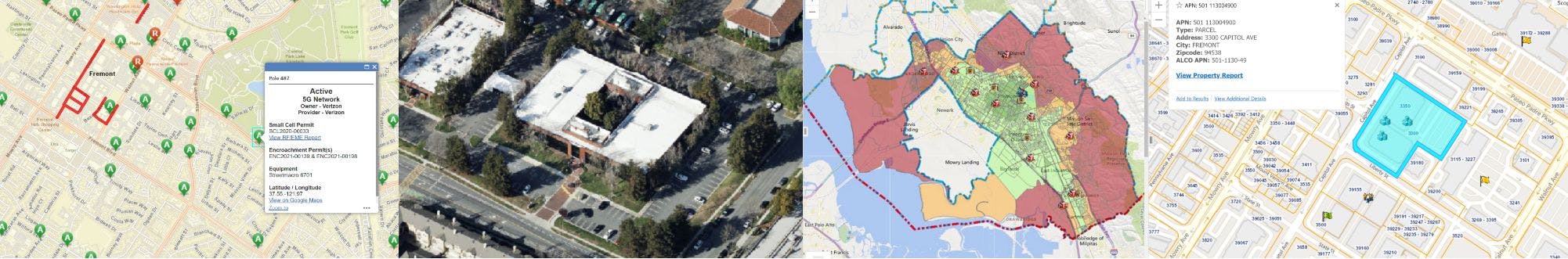
GIS develops and designs maps, interactive apps, and data to help the Fremont Community and the City Organization understand and visualize information. One example is the City’s Open Data Hub which is an online library and reference tool to provide easy access to City maps, data sets, websites, story maps, and applications. Containing an abundance of both internal and external resources, there is something useful for everyone. It can help you find what district you live in, who your council member is, when PG&E schedules public safety power outages, how to submit planning permits, and much more.
GIS is a division of the Information Technology Services Department.
The Geographic Information Systems Division (GIS) is developing a 5-year Strategic Plan which will be used as a guide to update and improve its services and/or products. Your survey response will be used in the development of the Strategic Plan.
GIS develops and designs maps, interactive apps, and data to help the Fremont Community and the City Organization understand and visualize information. One example is the City’s Open Data Hub which is an online library and reference tool to provide easy access to City maps, data sets, websites, story maps, and applications. Containing an abundance of both internal and external resources, there is something useful for everyone. It can help you find what district you live in, who your council member is, when PG&E schedules public safety power outages, how to submit planning permits, and much more.
GIS is a division of the Information Technology Services Department.